Free consultation

ABOUT THE CLIENT


The Gamuza company is responsible for the safety of power grids in Poland and European markets. It carries out comprehensive vegetation management along transmission and distribution infrastructure, operates over large geographical areas, and cooperates with numerous administrative units and property owners. The scale of operations covers thousands of locations requiring assessment, documentation, and coordination, which creates a highly complex operational environment.
ABOUT THE PROJECT

Gamuza sp. z o.o. approached us with a project to create a system that would enable a full digital mapping of the tree felling process based on geospatial data.
Previous activities were dispersed, inconsistent, and largely based on manual work, which significantly hindered operations management and business scaling. The main challenge was organizing work in a distributed environment. Many field workers carried out tasks simultaneously in multiple locations, while administrative support was handled by an office team.
INITIAL REQUIREMENTS / CONSULTING

The need to centralize dispersed activities
The client came to us with the problem of drastic data dispersion between over a hundred field workers and a ten-person office. They expected a cohesive digital environment that would replace manual information distribution and provide access to identical data for all roles in the company.
Information flow mapping
It was necessary to design a consistent data exchange model that would smoothly transform raw field coordinates into ready-to-process administrative records (including efficient identification of trees, owners, and plots).

CHALLENGE / ANALYSIS

Technological silo (QGIS vs Excel)
The main operational challenge was a complete lack of integration. Field technicians worked on Quantum GIS software, while administration handled thousands of consents and documents in Excel, which required continuous, manual data transfer between systems.
Overwhelmed by bureaucracy and errors
The necessity of manually searching for plot owners for thousands of locations led to a massive overload of the administration department, high susceptibility to human errors, and consequently – burdensome employee turnover.


Lack of fluency in coordination
Delays in transmitting data from the field to the office and back slowed down, among other things, power outage procedures on the grids, which in turn regularly paralyzed work during peak felling periods.
PROJECT GOALS
The overarching goal was to centralize and organize dispersed, slow processes, which was to forever free the administration from clogging bureaucracy and eliminate felling downtimes. We focused on providing a reliable flow of information, enforcing instant data correlation between field workers and the office.

Merging work environments
Combining raw geospatial data with the full administrative process, creating a single reliable environment facilitating the work of both technicians and clerks.

Automating data acquisition
Complete elimination of manual search for information about plots and owners, thereby relieving office workers of tedious, repetitive tasks.

Unification of formal processes
Implementation of standardized and digital paths for registering owner consents, power outage procedures, and documentation of completed fellings’ acceptances.

Instant information distribution
Ensuring the flow of updated data to field teams in real time, fully eliminating previous communication delays.

Increasing work predictability
Improving the quality of planning and coordination between the field and the office, which facilitates safe resource management during key operations on transmission lines.

Reduction of turnover and error rates
Designing an ergonomic and automated tool that will reduce the level of frustration and unnecessary work overload in the critical administration department.
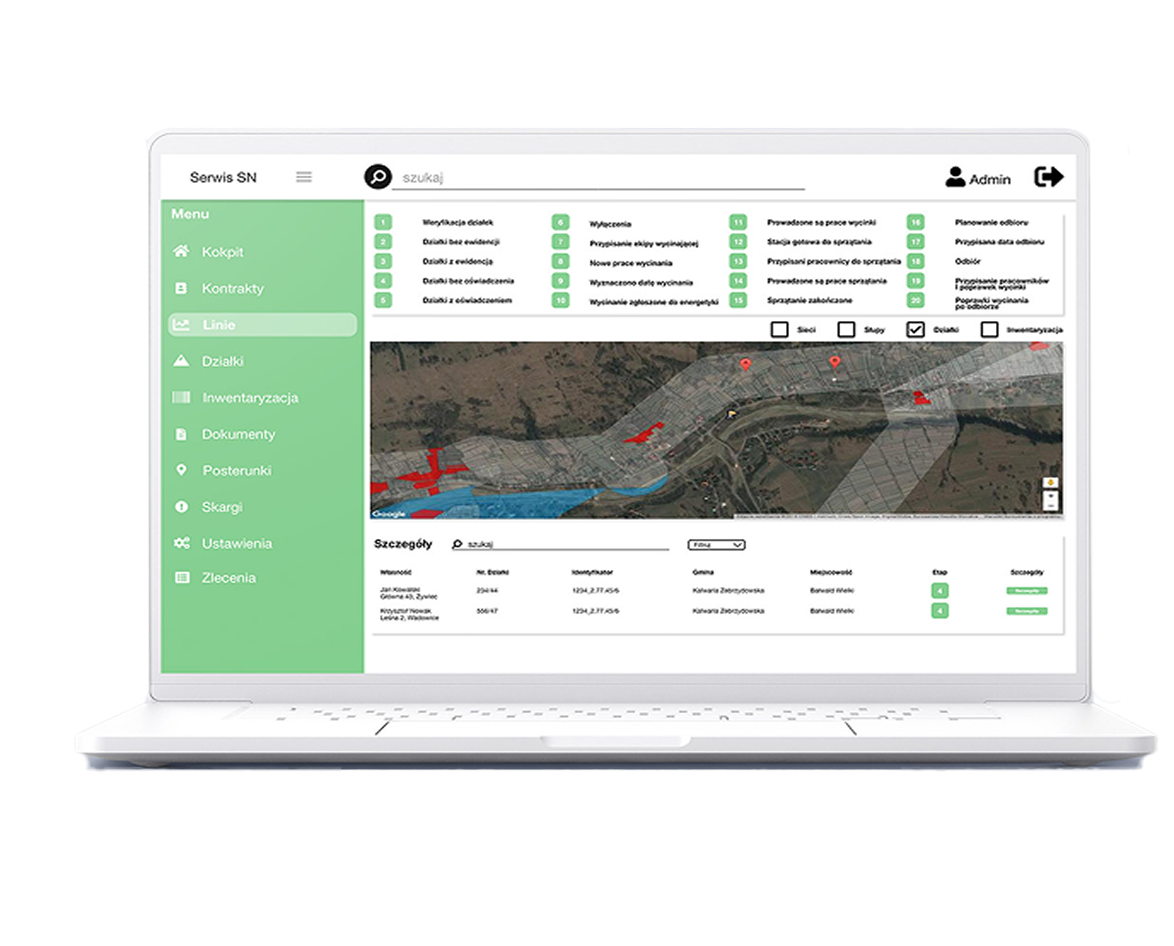
Solution description
The developed solution successfully merged raw field data, cadastral datasets from Geoportal, and the entire formal workflow into one centralized platform. The system now reflects every stage of felling – from the inventory of a single tree, through the automatic assignment of the land registry number, to the planning of power outages and the generation of acceptance documentation.
PROJECT DETAILS / IMPLEMENTATION
The constructed architecture is based on the direct integration of field equipment with state systems in a way that is almost invisible yet rigorously efficient for the entire administration.
Coordinates plotted by surveyors in Quantum GIS go to the database, where in a fraction of a second they acquire full registry parameters pulled live from Geoportal.
The platform, operating in a multi-role model, oversees all digital paths (outages, consents), additionally connecting with the external postal operator Envelo for full correspondence automation.
Such a closed and tight chain provides a secure environment for making strategic investment decisions, resistant to bureaucratic delays.
Integration with Quantum GIS and Geoportal
The system processes coordinates from the surveyor on the fly, automatically fetching the plot’s registry number and its owner’s data straight from state resources.
Dedicated administrative modules
Creation of a convenient environment guiding the employee step-by-step through registering consents, power outages, and compiling documentation.
Automating shipments with Envelo
Implementation of direct integration with the postal operator, allowing for automatic generation and mass mailing of letters to plot owners without manually filling out envelopes.
Multifunctional platform
Building a single work center for surveyors, project managers, administration, and felling managers, where everyone operates on the same views in real time.
Results and business
impact
The introduction of an integrated felling management system brought Gamuza significant operational benefits, successfully merging previously dispersed planning activities into a predictable, easy-to-supervise structure.
Shortening the time of acquiring information about plots and owners, because the identification process happens automatically based on coordinates.
Reducing the number of documentation errors thanks to standardization and moving away from working on dispersed Excel spreadsheets.
Reducing turnover in the administration department as a result of limiting the most burdensome and error-prone manual tasks.
Significantly relieving the administration department, which no longer has to handle thousands of records manually or prepare correspondence without system support.
Improving the coordination of surveyors, project managers, administration, and felling managers thanks to a single source of up-to-date information.
Increasing the predictability of field activities, which facilitates the planning of power outages and scheduling work in multiple locations simultaneously.
Increasing the operational efficiency of technicians, because field data is automatically linked to plots and reaches the administration without delays.
Facilitating supervision and reporting, because the entire felling process is monitored from one place, which supports making quick and accurate decisions.
Client testimonial

“Collaboration with the system development team was a huge support for us, because from the beginning they understood the complexity of our processes and were able to translate it into practical solutions. Every stage of the project was conducted in an orderly manner, and the proposed improvements resulted from real observations of work in the field and in administration. Thanks to this, we received a tool that truly meets our needs.”
Trusted by